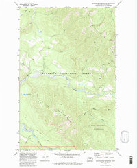
1970 Map of Spotted Bear Mountain
USGS Topo · Published 1980About this map
The Spotted Bear River winds through a landscape of high summits and deep drainage basins in this 1970 study. The confluence of the South Fork Flathead River and the Spotted Bear River occurs at the map's southern edge, marking a critical transition in the regional hydrology within the Flathead National Forest. This era preserves the primitive access routes of the Bob Marshall Wilderness, where the Spy Mountain Trail (Pack) and Green Mtn Trail (Pack) represent the primary network for forest management and backcountry travel. Notable peaks like Spotted Bear Mountain and Bent Mountain define the high country around Webb Lake and Spotted Bear Lake. The inclusion of a remote Lookout on the crest of Spotted Bear Mountain indicates the fire-watch infrastructure that was essential for protecting these timberlands before modern satellite monitoring became standard.
Find a feature on this map
28 named features on this map. Tap any name to fly to it.
Don’t see what you’re looking for? This feature index may not catch every label — zoom into the map to look around manually.
Map Details
Editions of this 1970 Spotted Bear Mountain Map
Other maps of this area

1913 · Marias Pass
USGS Topo · 1:125,000

1914 · Nyack
USGS Topo · 1:125,000

1936 · Silvertip
USGS Topo · 1:96,000

1942 · Silvertip
USGS Topo · 1:125,000

1955 · Choteau
USGS Topo · 1:250,000

1957 · Choteau
USGS Topo · 1:250,000

1958 · Choteau
USGS Topo · 1:250,000

1958 · Capitol Mountain
USGS Topo · 1:24,000

1958 · Circus Peak
USGS Topo · 1:24,000

1958 · Horseshoe Peak
USGS Topo · 1:24,000