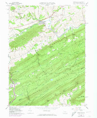
1966 Map of Spring Mills
USGS Topo · Published 1973About this map
Spring Mills stands as the primary hub of this valley landscape, where the confluence of Sinking Creek and Penns Creek shaped the early development of the region. This 1960s survey illustrates a rural corridor along the Penn Central railroad, linking small settlements like Penn Hall and Beaverdam through the heart of Penns Valley. The terrain is defined by a series of parallel ridges including Egg Hill and First Mountain, which separate the agricultural valley floor from the densely wooded tracts of Rothrock State Forest and Bald Eagle State Forest. Genealogy researchers will find significant detail in the placement of country houses of worship such as St Johns Ch and Bethesda Ch, alongside several family and community burial grounds like Union Cem and Paradise Cem. The map captures the area just as the Sidlerville Pike and secondary roads began to supersede the rail-and-water network of the previous century.
Find a feature on this map
77 named features on this map. Tap any name to fly to it.
Don’t see what you’re looking for? This feature index may not catch every label — zoom into the map to look around manually.
Map Details
Editions of this 1966 Spring Mills Map
4 editions found
Other maps of this area

1924 · Centre Hall
USGS Topo · 1:62,500

1924 · Lewistown
USGS Topo · 1:62,500

1925 · Mifflintown
USGS Topo · 1:48,000

1927 · Lewisburg
USGS Topo · 1:62,500

1929 · Centre Hall
USGS Topo · 1:62,500

1934 · Mifflintown
USGS Topo · 1:62,500

1937 · Mifflintown
USGS Topo · 1:62,500

1937 · Millheim
USGS Topo · 1:48,000

1941 · Millheim
USGS Topo · 1:62,500

1943 · Lewistown
USGS Topo · 1:125,000