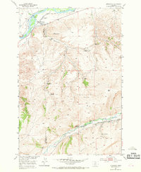
1951 Map of Springdale
USGS Topo · Published 1969About this map
The Yellowstone River and the Northern Pacific railroad define the northern corridor of this territory at the boundary of Park and Sweet Grass counties. The landscape transitions from the river valley into a high-relief interior where numerous family landholdings are documented, reflecting the ranching and homesteading history of mid-century Montana. Settlements such as Springdale and the Springdale Ranch anchor the northern reach, while a network of isolated sites like the Hash Homestead (Aban'd), Olson Homestead, and Bert Woods Homestead are scattered across the drainages of Mendenhall Creek and Jarrett Creek. To the south, the topography drops toward the West Boulder River, bounded by the prominent geological feature of the Coal Mine Rim. This documentation provides a clear look at the distribution of remote residences and the vital role of natural water sources like Chicken Creek and Spring Creek in sustaining the local agrarian economy.
Find a feature on this map
31 named features on this map. Tap any name to fly to it.
Don’t see what you’re looking for? This feature index may not catch every label — zoom into the map to look around manually.
Map Details
Editions of this 1951 Springdale Map
4 editions found
Other maps of this area

1891 · Livingston
USGS Topo · 1:250,000

1893 · Livingston
USGS Topo · 1:250,000

1947 · Bozeman
USGS Topo · 1:250,000

1948 · Bozeman
USGS Topo · 1:250,000

1951 · Mount Rae
USGS Topo · 1:24,000

1951 · Squaw Peak
USGS Topo · 1:24,000

1951 · Kelly Hills
USGS Topo · 1:24,000

1951 · Springdale
USGS Topo · 1:24,000

1951 · Mc Leod Basin
USGS Topo · 1:24,000

1951 · Hunters Hot Springs
USGS Topo · 1:24,000