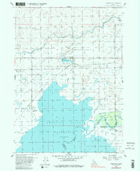
1955 Map of Springfield
USGS Topo · Published 1983About this map
The American Falls Reservoir dominates the southern landscape of this mid-century Idaho survey, defining the shoreline for the settlements of Springfield and Sterling. The area represents a complex intersection of historic transit and modern irrigation, where the Oregon Trail passes near the Fort Hall Historic Monument within the Fort Hall Indian Reservation. An intricate network of water management, including the Aberdeen Springfield Canal and the Low Line Canal, supports the agricultural character of the high desert terrain. The Union Pacific railroad cuts through the territory, passing the Bird Haven area and several local landmarks like the Cem near Springfield. This record illustrates the transition from the pioneer era to the developed irrigation systems that transformed the Snake River Plain, preserving the locations of early monuments and family-named roads like Judge Road and Cushman Road.
Find a feature on this map
31 named features on this map. Tap any name to fly to it.
Don’t see what you’re looking for? This feature index may not catch every label — zoom into the map to look around manually.
Map Details
Editions of this 1955 Springfield Map
3 editions found
Other maps of this area

1934 · American Falls
USGS Topo · 1:62,500

1934 · Michaud
USGS Topo · 1:62,500

1936 · American Falls
USGS Topo · 1:62,500

1937 · Michaud
USGS Topo · 1:62,500

1954 · Pocatello
USGS Topo · 1:250,000

1955 · Springfield NW
USGS Topo · 1:24,000

1955 · Rockford
USGS Topo · 1:24,000

1955 · Pingree
USGS Topo · 1:24,000

1955 · Springfield
USGS Topo · 1:24,000

1955 · Idaho Falls
USGS Topo · 1:250,000