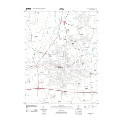
2010 Map of Springfield
USGS Topo · Published 2010About this map
The city of Springfield is the focal point of this 2010 study, showing a mature urban landscape at the confluence of the Mad River and Buck Creek. The map documents a dense network of residential subdivisions and suburban developments that surround the city center, including Ridgewood, Eastview Heights, and Sherwood Park. For local history and genealogy, the map is remarkably detailed in its recording of burial grounds, ranging from the central Ferncliff Cemetery and Old Columbia Street Cemetery to the peripheral Emery Chapel Cemetery and Calvary Cemetery. Educational and scientific institutions like Wittenberg University and the Weaver Observatory are clearly marked, while the industrial and agricultural origins of the area are reflected in labels like Snyders Mill. The western edges of the sheet show the transition to more open land, with landmarks like Logans Chance Airport and the Snyder Park Golf Course punctuating the river valley.
Find a feature on this map
106 named features on this map. Tap any name to fly to it.
Don’t see what you’re looking for? This feature index may not catch every label — zoom into the map to look around manually.
Map Details
Editions of this 2010 Springfield Map
This is the sole edition of this map. No revisions or reprints were ever made.
Other maps of this area

1904 · Springfield
USGS Topo · 1:62,500

1906 · Springfield
USGS Topo · 1:62,500

1907 · South Charleston
USGS Topo · 1:62,500

1914 · St. Paris
USGS Topo · 1:62,500

1914 · Mechanicsburg
USGS Topo · 1:62,500

1916 · Mechanicsburg
USGS Topo · 1:62,500

1916 · St. Paris
USGS Topo · 1:62,500

1944 · Mechanicsburg
USGS Topo · 1:62,500

1944 · St. Paris
USGS Topo · 1:62,500

1947 · Columbus
USGS Topo · 1:250,000
Featured Places
- Springfield, OH
- Happy Valley Mobile Home Park, OH
- Limecrest, OH
- Beatty, OH
- Rose Garden Mobile Home Park, OH