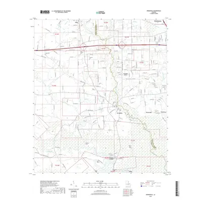
2018 Map of Springfield
USGS Topo · Published 2018About this map
The Blood River and Tickfaw River define the watery landscape of this Tangipahoa and Livingston Parish region, where historic river landings once anchored local commerce. At Springfield, the convergence of major local routes and the Natalbany River highlights a long-standing hub of settlement, while smaller communities like Albany and Wadesboro are marked by their proximity to the area's shifting bayous and creeks. A distinct concentration of cultural sites is visible north of Springfield, including the Hungarian Cem and Saint Margarets Cem, which point to the diverse heritage of the early settlers here. To the south, the terrain transitions into a more swampy lowland characterized by features such as Brier Patch Island and Jack Island, reflecting the river-and-marsh environment that historically shaped transportation and trade before modern highways.
Find a feature on this map
178 named features on this map. Tap any name to fly to it.
Don’t see what you’re looking for? This feature index may not catch every label — zoom into the map to look around manually.
Map Details
Editions of this 2018 Springfield Map
This is the sole edition of this map. No revisions or reprints were ever made.
Other maps of this area

1934 · Springfield
USGS Topo · 1:62,500

1935 · Ponchatoula
USGS Topo · 1:62,500

1939 · Ponchatoula
USGS Topo · 1:62,500

1939 · Springfield
USGS Topo · 1:62,500

1940 · Tickfaw
USGS Topo · 1:31,680

1949 · Albany
USGS Topo · 1:31,680

1950 · Doyle
USGS Topo · 1:31,680

1951 · Ponchatoula
USGS Topo · 1:62,500

1954 · Baton Rouge
USGS Topo · 1:250,000

1956 · Baton Rouge
USGS Topo · 1:250,000