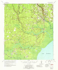
1965 Map of Springfield
USGS Topo · Published 1965About this map
Livingston and Springfield anchor this mid-1960s study of the Louisiana lowlands, where the Tickfaw River and Blood River wind toward Lake Maurepas. The map captures a unique cultural landscape in the Hungarian Settlement north of Albany, alongside numerous rural landmarks like the Albany-Springfield High Sch and the Springville Lookout Tower. Navigation remains central to the area's geography, with various points marked as the Head of Navigation and several historic landings preserved, including Warsaw Landing and Tiger Bluff Landing. The intricate water network is defined by island formations like Steam Island and Jack Island, and extensive wetlands such as Gum Swamp and Bull Run Swamp. Local genealogy is well-represented through family-named sites like Smiley Cem, Davidson Cem, and the church at St Margarets Ch.
Find a feature on this map
113 named features on this map. Tap any name to fly to it.
Don’t see what you’re looking for? This feature index may not catch every label — zoom into the map to look around manually.
Map Details
Editions of this 1965 Springfield Map
This is the sole edition of this map. No revisions or reprints were ever made.
Other maps of this area

1892 · Mount Airy
USGS Topo · 1:62,500

1892 · Bonnet Carre
USGS Topo · 1:62,500

1892 · Donaldsonville
USGS Topo · 1:62,500

1934 · Denham Springs
USGS Topo · 1:62,500

1934 · Springfield
USGS Topo · 1:62,500

1935 · Ponchatoula
USGS Topo · 1:62,500

1936 · Ruddock
USGS Topo · 1:31,680

1936 · Bonnet Carre
USGS Topo · 1:62,500

1939 · Ponchatoula
USGS Topo · 1:62,500

1939 · Springfield
USGS Topo · 1:62,500