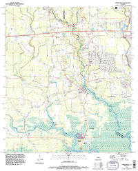
1994 Map of Springfield
USGS Topo · Published 1996About this map
The Tickfaw River and Natalbany River dominate this mid-1990s view of the border between Livingston Parish and Tangipahoa Parish. Settlement clusters along the Highway 190 corridor near Albany and the Interstate 12 interchange contrast with the swampy, low-lying bottomlands to the south. The convergence of these waterways creates a complex landscape of wetlands and islands, including Jack Island and Brier Patch Island, leading down toward the Warsaw Landing area.
Find a feature on this map
31 named features on this map. Tap any name to fly to it.
Don’t see what you’re looking for? This feature index may not catch every label — zoom into the map to look around manually.
Map Details
Editions of this 1994 Springfield Map
This is the sole edition of this map. No revisions or reprints were ever made.
Other maps of this area

1934 · Springfield
USGS Topo · 1:62,500

1935 · Ponchatoula
USGS Topo · 1:62,500

1939 · Ponchatoula
USGS Topo · 1:62,500

1939 · Springfield
USGS Topo · 1:62,500

1940 · Tickfaw
USGS Topo · 1:31,680

1949 · Albany
USGS Topo · 1:31,680

1950 · Doyle
USGS Topo · 1:31,680

1951 · Ponchatoula
USGS Topo · 1:62,500

1954 · Baton Rouge
USGS Topo · 1:250,000

1956 · Baton Rouge
USGS Topo · 1:250,000