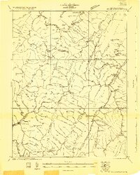
1922 Map of Spruce Knob
USGS Topo · Published 1922About this map
Spruce Knob stands as the high point of this high-altitude landscape surveyed in the early 1920s, a period when rural schoolhouses and small post offices defined community life in the Allegheny Mountain region. The mapping reveals a dense network of mountain settlements and infrastructure, including the logging-era operations near Thornwood and Winterburn Station. Local education was decentralized, as evidenced by the distribution of numerous neighborhood institutions like Hinkle School, Dam School, and Stark School.
Find a feature on this map
113 named features on this map. Tap any name to fly to it.
Don’t see what you’re looking for? This feature index may not catch every label — zoom into the map to look around manually.
Map Details
Editions of this 1922 Spruce Knob Map
3 editions found

Other maps of this area

1889 · Beverly
USGS Topo · 1:125,000

1892 · Beverly
USGS Topo · 1:125,000

1892 · Franklin
USGS Topo · 1:125,000

1894 · Staunton
USGS Topo · 1:125,000

1896 · Franklin
USGS Topo · 1:125,000

1901 · Monterey
USGS Topo · 1:125,000

1909 · Elkins
USGS Topo · 1:62,500

1920 · Onego
USGS Topo · 1:62,500

1921 · Onego
USGS Topo · 1:48,000

1922 · Onego
USGS Topo · 1:62,500