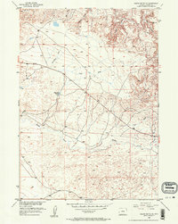
1952 Map of Squaw Butte NE
USGS Topo · Published 1953About this map
Poison Creek winds through the heart of this Fremont County landscape, defining the drainage patterns of an area mapped during the early 1950s as part of the Department of the Interior program for the development of the Missouri River Basin. The terrain is a complex network of ephemeral waterways and high points, including the prominent VABM 5738 Fence and VABM 5544 Walk benchmarks. A central landmark for local water management is the Dinty Moore Reservoir, which sits at the intersection of several topographic features. Deep incisions in the earth are named for earlier inhabitants or geological characteristics, such as Wickersham Draw, Gates Draw, and Coal Draw. These labels suggest a history of ranching and resource exploration in this section of Wyoming, where the unimproved dirt roads and trails provided the primary means of traversal through Felix Gulch and across the wide plains of Linn Draw.
Find a feature on this map
9 named features on this map. Tap any name to fly to it.
Don’t see what you’re looking for? This feature index may not catch every label — zoom into the map to look around manually.
Map Details
Editions of this 1952 Squaw Butte NE Map
3 editions found
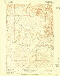
Other maps of this area

1952 · Seventy-one Reservoir
USGS Topo · 1:24,000

1952 · Squaw Butte NE
USGS Topo · 1:24,000

1952 · Squaw Butte
USGS Topo · 1:24,000

1952 · Ocla Draw
USGS Topo · 1:24,000

1952 · Gates Butte
USGS Topo · 1:24,000

1952 · Moneta
USGS Topo · 1:24,000

1952 · Picard Ranch
USGS Topo · 1:24,000

1952 · Lysite
USGS Topo · 1:24,000

1952 · Haybarn Hill
USGS Topo · 1:24,000

1955 · Arminto
USGS Topo · 1:250,000