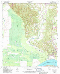
1965 Map of St. Francisville
USGS Topo · Published 1994About this map
St Francisville occupies the high ground overlooking the wide bottomlands of the Mississippi River, serving as a focal point for West Feliciana Parish during the mid-1960s. The landscape transitions sharply from the elevated bluffs around Bains and Hardwood down into the expansive Tunica Swamp, a dense network of water bodies including Blackfork Lake, Davis Lake, and Ratcliff Lake. This survey illustrates the intricate relationship between the region's plantation history and its geography, noting the Catalpa Plantation and several family-named landmarks. Educational and spiritual centers like the Dawson Sch, Bains Sch, and Afton Villa Ch are well-documented, alongside numerous burial sites such as Barrow Cem and Hebrew Rest Cem. The presence of an Old Railroad Grade winding through the swamp towards the river indicates the shifting infrastructure of the riverfront economy.
Find a feature on this map
39 named features on this map. Tap any name to fly to it.
Don’t see what you’re looking for? This feature index may not catch every label — zoom into the map to look around manually.
Map Details
Editions of this 1965 St. Francisville Map
3 editions found
Other maps of this area

1906 · Bayou Sara
USGS Topo · 1:125,000

1939 · St. Francisville
USGS Topo · 1:62,500

1939 · Fordoche
USGS Topo · 1:62,500

1941 · Batchelor
USGS Topo · 1:62,500

1953 · New Roads
USGS Topo · 1:24,000

1954 · Port Hudson
USGS Topo · 1:24,000

1954 · Elm Park
USGS Topo · 1:24,000

1954 · Baton Rouge
USGS Topo · 1:250,000

1955 · Fordoche
USGS Topo · 1:62,500

1955 · Batchelor
USGS Topo · 1:62,500
Featured Places
- Saint Francisville, St. Francisville
- St. Francisville, LA
- Bains, LA
- Solitude, LA
- Pointe Coupee Parish, LA