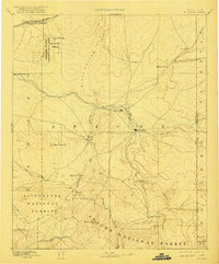
1892 Map of St Johns
USGS Topo · Published 1921About this map
St Johns serves as the focal point for this late nineteenth-century survey, situated at the confluence of the Little Colorado River and Zuni River systems. The landscape reflects an era of early Territorial-era settlement and infrastructure, with the Atlantic and Pacific Railroad cutting through the northern reaches near the Puerco River. To the west, the early boundaries of the Petrified Forest National Monument are already defined, preserving a geologic wonder alongside established cattle-country landmarks like Windmill Ranch and Mexican Crossing.
Find a feature on this map
37 named features on this map. Tap any name to fly to it.
Don’t see what you’re looking for? This feature index may not catch every label — zoom into the map to look around manually.
Map Details
Editions of this 1892 St Johns Map
5 editions found
Other maps of this area

1883 · Tusayan
USGS Topo · 1:250,000

1886 · St Johns
USGS Topo · 1:250,000

1886 · Wingate
USGS Topo · 1:250,000

1886 · Tusayan
USGS Topo · 1:250,000

1886 · Fort Defiance
USGS Topo · 1:250,000

1886 · Holbrook
USGS Topo · 1:250,000

1892 · Fort Defiance
USGS Topo · 1:250,000

1892 · St Johns
USGS Topo · 1:250,000

1892 · Wingate
USGS Topo · 1:250,000

1893 · Holbrook
USGS Topo · 1:250,000