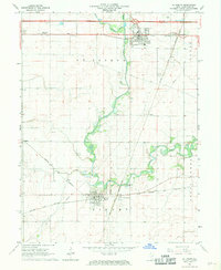
1968 Map of St. Joseph
USGS Topo · Published 1969About this map
St Joseph and Sidney serve as the primary hubs in this late-1960s agricultural landscape, where the confluence of several major rail lines once defined local commerce. The winding path of the Salt Fork river cuts through the central terrain, bordered by the Saline Branch Drainage Ditch to the north. These waterways and the surrounding prairie are crisscrossed by a dense network of transit, including the Penn Central, Norfolk and Western, and Chicago and Eastern Illinois railroads.
Find a feature on this map
27 named features on this map. Tap any name to fly to it.
Don’t see what you’re looking for? This feature index may not catch every label — zoom into the map to look around manually.
Map Details
Editions of this 1968 St. Joseph Map
This is the sole edition of this map. No revisions or reprints were ever made.
Other maps of this area

1906 · Urbana
USGS Topo · 1:62,500

1931 · Fithian
USGS Topo · 1:48,000

1943 · Fithian
USGS Topo · 1:62,500

1953 · Danville
USGS Topo · 1:250,000

1953 · Indianapolis
USGS Topo · 1:250,000

1955 · Danville
USGS Topo · 1:250,000

1956 · Danville
USGS Topo · 1:250,000

1956 · Indianapolis
USGS Topo · 1:250,000

1956 · Newman
USGS Topo · 1:62,500

1956 · Villa Grove
USGS Topo · 1:62,500