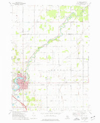
1973 Map of St. Louis
USGS Topo · Published 1977About this map
The winding course of the Pine River dictates the layout of the region, flowing from the northwest through the heart of St. Louis before heading east. This 1970s landscape is defined by its industrial foundations, particularly the numerous Brine Wells and Oil Wells scattered across the surrounding townships of Jasper and Bethany. The city itself is a dense hub of civic and educational life, featuring St Louis Sch, Nurnberger Sch, and the centrally located City Hall.
Find a feature on this map
60 named features on this map. Tap any name to fly to it.
Don’t see what you’re looking for? This feature index may not catch every label — zoom into the map to look around manually.
Map Details
Editions of this 1973 St. Louis Map
This is the sole edition of this map. No revisions or reprints were ever made.
Other maps of this area

1930 · Shepherd
USGS Topo · 1:48,000

1934 · Sanford
USGS Topo · 1:62,500

1934 · Merrill
USGS Topo · 1:62,500

1935 · Alma
USGS Topo · 1:62,500

1936 · Shepherd
USGS Topo · 1:62,500

1936 · Sanford
USGS Topo · 1:62,500

1937 · Merrill
USGS Topo · 1:62,500

1938 · Alma
USGS Topo · 1:62,500

1954 · Midland
USGS Topo · 1:250,000

1958 · Midland
USGS Topo · 1:250,000