1949 Map of St. Louis
USGS Topo · Published 1949About this map
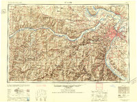
The confluence of the Mississippi River and Missouri River anchors this regional study, revealing the dense industrial and transit hub of St Louis just after the war. In the east, the complex rail yards and riverfront works of East St Louis and Granite City sit opposite the Missouri metropolis, supported by a massive web of tracks including the Terminal RR Assn of St Louis and Wabash RR.
Find a feature on this map
138 named features on this map. Tap any name to fly to it.
Don’t see what you’re looking for? This feature index may not catch every label — zoom into the map to look around manually.
Map Details
Editions of this 1949 St. Louis Map
2 editions found

Other maps of this area

1886 · Jefferson City
USGS Topo · 1:125,000

1888 · Tuscumbia
USGS Topo · 1:125,000

1888 · St. Louis
USGS Topo · 1:62,500

1890 · Louisiana
USGS Topo · 1:125,000

1890 · Mexico
USGS Topo · 1:125,000

1890 · Moberly
USGS Topo · 1:125,000

1890 · Hermann
USGS Topo · 1:125,000

1890 · Fulton
USGS Topo · 1:125,000

1894 · Tuscumbia
USGS Topo · 1:125,000

1894 · Jefferson City
USGS Topo · 1:125,000