1943 Map of St. Paul
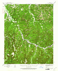
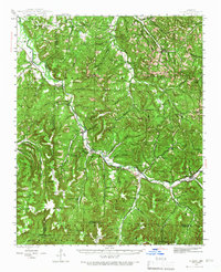
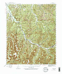
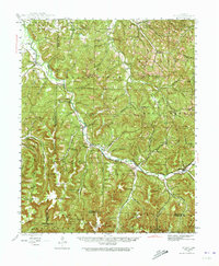
USGS Topo · Published 1961About this map
The White River carves a deep valley through the Ozark landscape of Madison County, serving as the primary corridor for settlement and transportation in the early 1940s. Small rural communities like St Paul and Delaney are positioned along its course, connected by State Route 16. This era shows a high density of rural schoolhouses and churches, such as Mt Liberty Sch and Brannon Ch, which served dispersed homesteads across the mountainous terrain. The map captures the region's transition into the Ozark National Forest, particularly in the southern reaches toward Mountain Crest. Notable local history is preserved in the numerous family-named landmarks and cemeteries, including the Dunaway Cem and Patrick Cem, which provide a detailed record of the families who settled these hollows. The presence of the Lily Gap Tower and various mountain peaks like Massey Mtn reflect the surveyor's focus on the verticality of this part of Arkansas.
Find a feature on this map
117 named features on this map. Tap any name to fly to it.
Don’t see what you’re looking for? This feature index may not catch every label — zoom into the map to look around manually.
Map Details
Editions of this 1943 St. Paul Map
5 editions found

Other maps of this area

1879 · Cravens
USGS Topo · 1:62,500

1887 · Watalula
USGS Topo · 1:62,500

1898 · Winslow #4
USGS Topo · 1:62,500

1898 · Winslow
USGS Topo · 1:125,000

1899 · Fayetteville
USGS Topo · 1:125,000

1900 · Eureka Springs
USGS Topo · 1:125,000

1901 · Winslow
USGS Topo · 1:125,000

1901 · Eureka Springs
USGS Topo · 1:125,000

1901 · Fayetteville
USGS Topo · 1:125,000

1904 · Fayetteville
USGS Topo · 1:125,000