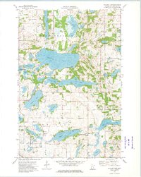
1973 Map of Stalker Lake
USGS Topo · Published 1975About this map
The glacial terrain of Tordenskjold and Eagle Lake townships is defined by a dense network of kettle lakes and wetlands, centered on the expansive Stalker Lake. This 1970s landscape reflects a settled rural community supported by institutions like the Tordenskjold Ch and Bethel Ch, alongside several burial grounds including St Olaf Cem and Lakeside Cem. Small-scale infrastructure such as the Townhall and a Radio Tower punctuate the farmsteads, while the natural environment is preserved in part through the National Waterfowl Production Area. The hydrography is particularly complex, featuring a variety of named basins like Johannes Lake, Sewell Lake, and the notably dry Whitman Lakebed. The presence of numerous Gravel Pits suggests the localized extraction of glacial deposits for road maintenance and building during this era.
Find a feature on this map
28 named features on this map. Tap any name to fly to it.
Don’t see what you’re looking for? This feature index may not catch every label — zoom into the map to look around manually.
Map Details
Editions of this 1973 Stalker Lake Map
This is the sole edition of this map. No revisions or reprints were ever made.
Other maps of this area

1912 · Battle Lake
USGS Topo · 1:62,500

1913 · Ashby
USGS Topo · 1:62,500

1914 · Battle Lake
USGS Topo · 1:62,500

1915 · Underwood
USGS Topo · 1:62,500

1953 · Brainerd
USGS Topo · 1:250,000

1957 · Brainerd
USGS Topo · 1:250,000

1958 · Brainerd
USGS Topo · 1:250,000

1965 · Brainerd
USGS Topo · 1:250,000

1969 · Eagle Lake
USGS Topo · 1:24,000
1969 · Evansville
USGS Topo · 1:24,000
Featured Places
- Eagle Lake Township, MN
- Tordenskjold Township, MN
- Clitherall Township, MN
- Saint Olaf Township, MN
- Otter Tail County, MN