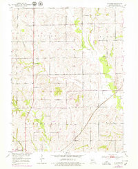
1951 Map of Standish
USGS Topo · Published 1979About this map
Van Horn Ridge dominates the northern landscape of this Missouri river basin survey, where small rural congregations like Van Horn Ch and Pleasant Hill Ch once served the local farming community. The southern portion of the map is defined by the critical transit corridor of the Atchison Topeka and Santa Fe railroad, which cuts diagonally through the terrain toward Carrollton. This rail infrastructure supported the small settlement of Standish, situated near the confluence of several small waterways including Cottonwood Branch and Standish Branch. The map reveals a highly structured rural society, with numerous churches and cemeteries such as Bethlehem Ch and St Marys Cem distributed across the drainage basins of Big Creek and Shootman Creek.
Find a feature on this map
26 named features on this map. Tap any name to fly to it.
Don’t see what you’re looking for? This feature index may not catch every label — zoom into the map to look around manually.
Map Details
Editions of this 1951 Standish Map
3 editions found
Other maps of this area

1889 · Lexington
USGS Topo · 1:125,000

1890 · Marshall
USGS Topo · 1:125,000

1892 · Marshall
USGS Topo · 1:125,000

1901 · Marshall
USGS Topo · 1:125,000

1924 · Dawn
USGS Topo · 1:62,500

1924 · Hale
USGS Topo · 1:62,500

1950 · Coloma
USGS Topo · 1:24,000

1950 · Hale
USGS Topo · 1:24,000

1951 · Hale
USGS Topo · 1:24,000

1951 · Bosworth
USGS Topo · 1:24,000