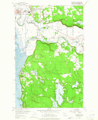
1956 Map of Stanwood
USGS Topo · Published 1965About this map
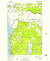
The Stillaguamish River snakes through the landscape, defining the character of the settlements it connects. In the north, the twin towns of Stanwood and East Stanwood serve as a hub of activity, featuring Lincoln High School and the Great Northern railway line. To the south, the terrain transitions into the lake-studded uplands, where Lake Goodwin, Lake Martha, and Lake Ki are central landmarks. The map illustrates a complex water management system with Tide Gates along Irvine Slough and Hat Slough, protecting low-lying lands from the tides of Port Susan. Farther inland, the small community of Silvana sits near the Silvana Terraces, while Happy Valley opens up to the south, highlighting the agricultural and recreational balance of the region. Local community life is evidenced by several sites including the Wenberg State Park and the Marysville Rifle Club.
Find a feature on this map
43 named features on this map. Tap any name to fly to it.
Don’t see what you’re looking for? This feature index may not catch every label — zoom into the map to look around manually.
Map Details
Editions of this 1956 Stanwood Map
5 editions found
Other maps of this area

1911 · Mount Vernon
USGS Topo · 1:125,000

1940 · Mt Vernon
USGS Topo · 1:62,500

1941 · Marysville
USGS Topo · 1:62,500

1943 · Marysville
USGS Topo · 1:62,500

1943 · Mt Vernon
USGS Topo · 1:62,500

1943 · Stanwood
USGS Topo · 1:62,500

1944 · Clear Lake
USGS Topo · 1:62,500

1956 · Tulalip
USGS Topo · 1:24,000

1956 · Arlington West
USGS Topo · 1:24,000
1956 · Stanwood
USGS Topo · 1:24,000