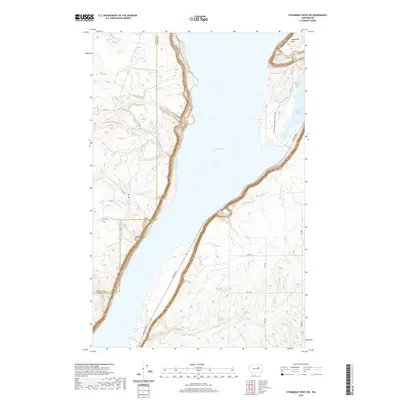
2020 Map of Steamboat Rock SW
USGS Topo · Published 2020About this map
Banks Lake dominates the central portion of this landscape, a significant reservoir filling the Grand Coulee floor. The eastern shore is marked by the massive basalt formation of Steamboat Rock, while the water's edge includes sheltered features like Devils Punch Bowl. This 2020 record illustrates the modern infrastructure serving the area, including Coulee Blvd and the Steamboat Rock Park Entrance Rd, which facilitate access to the recreational and geographical landmarks along the coulee. Several small drainages, including Rusho Cr, Ladds Cr, and Lower Lewis Cr, flow toward the lake from the surrounding high plateaus. The map also delineates the boundary between Douglas and Grant counties, cutting through the western upland terrain north of 13th Rd NE.
Find a feature on this map
22 named features on this map. Tap any name to fly to it.
Don’t see what you’re looking for? This feature index may not catch every label — zoom into the map to look around manually.
Map Details
Editions of this 2020 Steamboat Rock SW Map
This is the sole edition of this map. No revisions or reprints were ever made.
Other maps of this area

1930 · Grand Coulee Sheet 3
USGS Topo · 1:31,680

1953 · Ritzville
USGS Topo · 1:250,000

1959 · Ritzville
USGS Topo · 1:250,000

1965 · Ritzville
USGS Topo · 1:250,000

1965 · Mold
USGS Topo · 1:24,000

1968 · Steamboat Rock SW
USGS Topo · 1:24,000

1968 · Barker Canyon
USGS Topo · 1:24,000

1968 · Hartline
USGS Topo · 1:24,000

1968 · Foster Coulee
USGS Topo · 1:24,000

1968 · Steamboat Rock SE
USGS Topo · 1:24,000