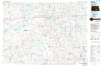
1985 Map of Steele
USGS Topo · Published 1994About this map
Steele serves as a primary hub within this expansive section of central North Dakota, where the transport corridor of Interstate 94 and the Burlington Northern railroad cut through a landscape defined by glacial activity. The map reveals an incredible density of wetlands and protected areas, such as the Chase Lake National Wildlife Refuge and Slade National Wildlife Refuge, indicating the region's importance for migratory birds and waterfowl. To the south, the Streeter Moraine and Streeter Flats dominate the terrain, surrounding smaller rural communities like Napoleon and Gackle. The presence of many alkali lakes, including the large Alkaline Lake, speaks to the unique hydrology of the Missouri Coteau. Small railway stops and unincorporated areas like Ladoga and Crystal Springs are shown alongside larger county seats, providing a detailed look at the 1980s rural settlement pattern.
Find a feature on this map
110 named features on this map. Tap any name to fly to it.
Don’t see what you’re looking for? This feature index may not catch every label — zoom into the map to look around manually.
Map Details
Editions of this 1985 Steele Map
This is the sole edition of this map. No revisions or reprints were ever made.
Other maps of this area

1896 · Jamestown
USGS Topo · 1:125,000

1896 · Edgeley
USGS Topo · 1:125,000

1900 · Pingree
USGS Topo · 1:125,000

1900 · Pingree
USGS Topo · 1:62,500

1925 · Edgeley
USGS Topo · 1:125,000

1951 · Driscoll
USGS Topo · 1:62,500

1951 · Eldridge NW
USGS Topo · 1:24,000

1952 · Jud NW
USGS Topo · 1:24,000

1952 · Tappen South
USGS Topo · 1:24,000

1952 · Tappen SE
USGS Topo · 1:24,000