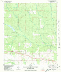
1980 Map of Steelwood Lake
USGS Topo · Published 1981About this map
The Styx River dominates this Baldwin County landscape, winding through a dense network of tributaries including Reedy Creek and Flat Creek. In the 1980s, the area around Rosinton and the northern edge of Loxley showed a distinct transition from riparian wetlands to organized rural settlements. Local history is anchored by landmarks like Rosinton Ch and the Styx River Ch, alongside the Dyes Cem near Coppers Lake.
Find a feature on this map
30 named features on this map. Tap any name to fly to it.
Don’t see what you’re looking for? This feature index may not catch every label — zoom into the map to look around manually.
Map Details
Editions of this 1980 Steelwood Lake Map
2 editions found
Other maps of this area

1920 · Robertsdale
USGS Topo · 1:62,500

1921 · Fairhope
USGS Topo · 1:62,500

1940 · Silverhill
USGS Topo · 1:31,680

1941 · Silverhill
USGS Topo · 1:31,680

1941 · Bay Minette
USGS Topo · 1:62,500

1941 · Robertsdale
USGS Topo · 1:62,500

1941 · Fairhope
USGS Topo · 1:62,500
1942 · Silverhill
USGS Topo · 1:31,680

1942 · Dyas
USGS Topo · 1:62,500

1943 · Robertsdale
USGS Topo · 1:62,500