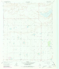
1962 Map of Stegall
USGS Topo · Published 1981About this map
Coyote Lake dominates the northeastern landscape of this West Texas survey, set against a backdrop of the High Plains near the New Mexico border. The map documents a sparsely populated agricultural region in Bailey Co during the early 1960s, with later revisions from the late 1970s. The small settlement of Stegall serves as a local focal point, supported by infrastructure like the Williams Landing Strip and a prominent Pipeline cutting through the southern sections. This area is characterized by numerous small depressions and playas typical of the Llano Estacado, alongside scattered resource extraction sites such as a Gravel Pit and another pit located further east. The lack of dense road networks or major towns highlights the importance of localized ranching and farming hubs during this era of rural Texas development.
Find a feature on this map
7 named features on this map. Tap any name to fly to it.
Don’t see what you’re looking for? This feature index may not catch every label — zoom into the map to look around manually.
Map Details
Editions of this 1962 Stegall Map
2 editions found
Other maps of this area

1954 · Clovis
USGS Topo · 1:250,000

1954 · Brownfield
USGS Topo · 1:250,000

1957 · Arch
USGS Topo · 1:62,500

1958 · Brownfield
USGS Topo · 1:250,000

1958 · Clovis
USGS Topo · 1:250,000

1962 · Brownfield
USGS Topo · 1:250,000

1962 · Stegall
USGS Topo · 1:24,000

1962 · Birdwell Ranch
USGS Topo · 1:24,000

1962 · Baileyboro NE
USGS Topo · 1:24,000

1962 · Baileyboro
USGS Topo · 1:24,000