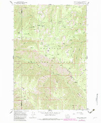
1967 Map of Stentz Spring
USGS Topo · Published 1983About this map
The Umatilla National Forest dominates this landscape in the Blue Mountains, showing a network of remote camps and forest service infrastructure in the late 1960s. The map highlights the rugged drainage of the Tucannon River and the Asotin Creek North Fork, where numerous family-named springs like Stentz Spring, Schneckloth Spring, and Sweeney Spring suggest early livestock grazing and water rights. Historical landmarks of the era include the Lookout Tower and Clearwater Guard Station, while recreation is evidenced by established sites such as Powell Camp and Ruchert Camp. The southeastern portion is marked by the Wenaha-Tucannon Wilderness, indicating the preservation of this backcountry terrain before modern development. Notable geological formations like the Devils Eyebrow and names like Hard-to-get-to Ridge reflect the challenging geography faced by travelers along the Pack Tr.
Find a feature on this map
63 named features on this map. Tap any name to fly to it.
Don’t see what you’re looking for? This feature index may not catch every label — zoom into the map to look around manually.
Map Details
Editions of this 1967 Stentz Spring Map
3 editions found

Other maps of this area

1937 · Pomeroy
USGS Topo · 1:96,000

1942 · Pomeroy
USGS Topo · 1:125,000

1943 · Peola
USGS Topo · 1:62,500

1943 · Saddle Butte
USGS Topo · 1:62,500

1946 · Saddle Butte
USGS Topo · 1:62,500

1946 · Peola
USGS Topo · 1:62,500

1955 · Pullman
USGS Topo · 1:250,000

1958 · Pullman
USGS Topo · 1:250,000

1967 · Rose Springs
USGS Topo · 1:24,000

1967 · Hopkins Ridge
USGS Topo · 1:24,000