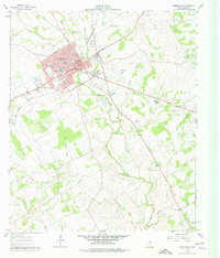
1961 Map of Stephenville
USGS Topo · Published 1976About this map
Stephenville serves as the focal point of this 1961 record, showing the community just as it was evolving around its educational and agricultural institutions. The presence of Tarleton State College and the Tarleton State College Farm highlights the town's identity as a center for higher learning and agricultural research, supported further by the Texas A & M College Substation No 20 to the north. The landscape is defined by the convergence of the North Bosque River and Alarm Creek, with the Gulf Colorado and Santa Fe railroad bisecting the town. Genealogists will find an exceptional density of burial sites including Mt Olive Cem, East Memorial Cem, and Johnson Cem. An Old Railroad Grade stretching south from the city limits offers a glimpse into earlier transportation corridors before the expansion of the Stephenville Municipal Airport.
Find a feature on this map
59 named features on this map. Tap any name to fly to it.
Don’t see what you’re looking for? This feature index may not catch every label — zoom into the map to look around manually.
Map Details
Editions of this 1961 Stephenville Map
4 editions found
Other maps of this area

1890 · Stephenville
USGS Topo · 1:125,000

1920 · Stephenville
USGS Topo · 1:125,000

1954 · Abilene
USGS Topo · 1:250,000

1958 · Abilene
USGS Topo · 1:250,000

1961 · Johnsville
USGS Topo · 1:24,000
1961 · Alexander
USGS Topo · 1:24,000

1961 · Knob Hill
USGS Topo · 1:24,000
1961 · Clairette
USGS Topo · 1:24,000

1961 · Stephenville
USGS Topo · 1:24,000
1965 · Dublin
USGS Topo · 1:24,000