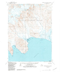
1963 Map of Stepovak Bay D-6
USGS Topo · Published 1984About this map
Alaska Peninsula National Wildlife Refuge dominates the upper half of this coastal landscape, protecting a roadless expanse of the Alaska Peninsula. The map details a complex intersection of land and sea where the Big River drains into the expansive Stepovak Bay. Along the shoreline, prominent landmarks like Lookout Hill and the Rock Wall provide orientation for mariners and researchers, while the low-lying Stepanof Flats and various Tidal Flats indicate the dynamic estuarine environment. To the southwest, the terrain rises toward Red Hill before dropping into Clark Bay and Grub Gulch. This survey, based on early 1960s photography, documents the wild geography of the Kupreanof Peninsula and Dent Point before the formal establishment of modern conservation boundaries, providing an essential record of this remote maritime frontier.
Find a feature on this map
15 named features on this map. Tap any name to fly to it.
Don’t see what you’re looking for? This feature index may not catch every label — zoom into the map to look around manually.
Map Details
Editions of this 1963 Stepovak Bay D-6 Map
3 editions found
Other maps of this area

1951 · Stepovak Bay
USGS Topo · 1:250,000

1953 · Port Moller
USGS Topo · 1:250,000
1963 · Stepovak Bay C-5 and C-6
USGS Topo · 1:63,360

1963 · Chignik A-6
USGS Topo · 1:63,360

1963 · Port Moller C-1
USGS Topo · 1:63,360

1963 · Chignik A-5
USGS Topo · 1:63,360

1963 · Chignik A-7
USGS Topo · 1:63,360

1963 · Stepovak Bay D-6
USGS Topo · 1:63,360

1963 · Stepovak Bay D-5
USGS Topo · 1:63,360

1963 · Chignik
USGS Topo · 1:250,000