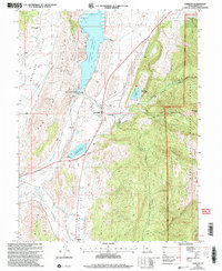
2001 Map of Sterling
USGS Topo · Published 2004About this map
The Sterling and Mayfield communities sit at the gateway to the high canyons of the Manti-La Sal National Forest in this 2001 revision of the Sanpete Valley. Water management is central to life here, evidenced by the large Gunnison Reservoir and Ninemile Reservoir, which feed the surrounding valley through a system of works including the San Pitch River, Twelvemile Creek, and various named ditches and canals. To the west, the Antelope Range and Antelope Valley Ranch define the drier terrain, while the eastern landscape rises sharply into Sixmile Canyon and Funk Canyon. Industrial and recreational footprints are found throughout, from the Morrison Mine and several quarries to the Palisade State Park and its Golf Course. A local cemetery and Gaging Station further mark the development of this rural corridor between the mountains.
Find a feature on this map
37 named features on this map. Tap any name to fly to it.
Don’t see what you’re looking for? This feature index may not catch every label — zoom into the map to look around manually.
Map Details
Editions of this 2001 Sterling Map
This is the sole edition of this map. No revisions or reprints were ever made.
Other maps of this area

1885 · Manti
USGS Topo · 1:250,000

1895 · Manti
USGS Topo · 1:250,000

1956 · Price
USGS Topo · 1:250,000

1960 · Price
USGS Topo · 1:250,000

1962 · Price
USGS Topo · 1:250,000
1965 · Woods Lake
USGS Topo · 1:24,000

1965 · Hells Kitchen Canyon SE
USGS Topo · 1:24,000
1965 · Mayfield
USGS Topo · 1:24,000

1965 · Manti
USGS Topo · 1:24,000

1965 · Black Mountain
USGS Topo · 1:24,000