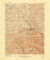
1935 Map of Steubenville
USGS Topo · Published 1958About this map
Ohio River industrial development and valley settlement dominate this mid-1930s survey of the tri-state border region. The city of Steubenville and the expanding footprint of Weirton anchor a landscape defined by heavy rail infrastructure, including the Pennsylvania RR and the Wheeling and Lake Erie RR. The survey captures the intricate topography of the Allegheny Plateau, where steep-walled runs like Island Creek and Cross Creek cut through the hills to reach the river valley. Numerous neighborhood developments and small mining or milling towns appear, such as La Belle View, Hollidays Cove, and Toronto. The transition from rural hilltop schools like Shady Glen Sch to the dense urban grids of the steel towns illustrates the era's shift toward concentrated industrial centers. This survey is particularly notable for detailing the many residential heights and terraces, such as Vermont Terrace and Pleasant Heights, that housed the region's workforce away from the river floor.
Find a feature on this map
102 named features on this map. Tap any name to fly to it.
Don’t see what you’re looking for? This feature index may not catch every label — zoom into the map to look around manually.
Map Details
Editions of this 1935 Steubenville Map
This is the sole edition of this map. No revisions or reprints were ever made.
Other maps of this area

1901 · Cadiz
USGS Topo · 1:62,500

1901 · Beaver
USGS Topo · 1:62,500

1902 · Wheeling
USGS Topo · 1:62,500

1903 · Cadiz
USGS Topo · 1:62,500

1904 · Wellsville
USGS Topo · 1:62,500

1904 · Steubenville
USGS Topo · 1:62,500

1904 · Beaver
USGS Topo · 1:62,500

1904 · Burgettstown
USGS Topo · 1:62,500

1905 · St. Clairsville
USGS Topo · 1:62,500
1905 · Salineville
USGS Topo · 1:62,500