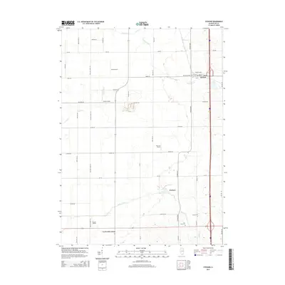
2015 Map of Steward
USGS Topo · Published 2015About this map
Steward serves as the primary hub in this portion of Lee County, situated where Steward Creek and Johns Cr converge. The landscape is defined by a dense grid of rural roads named for local families, such as Orouke Rd, Gittleson Rd, and Becker Rd, reflecting the deep agricultural roots of the region. A notable concentration of private aviation is evident across the township, with Staton Airport, Ranken Airport, and Hep Cats Airport punctuating the farmland. To the south, the small settlement of Scarboro sits near Dry Run, while Twelvemile Corner marks a distinct crossroads. For genealogists, the map identifies several burial grounds including Steward Cemetary, German Cem, and Twin Grove Cem, providing vital clues for family history research in this Illinois prairie landscape.
Find a feature on this map
44 named features on this map. Tap any name to fly to it.
Don’t see what you’re looking for? This feature index may not catch every label — zoom into the map to look around manually.
Map Details
Editions of this 2015 Steward Map
This is the sole edition of this map. No revisions or reprints were ever made.
Other maps of this area

1934 · De Kalb
USGS Topo · 1:62,500

1937 · De Kalb
USGS Topo · 1:62,500

1951 · Earlville
USGS Topo · 1:62,500

1952 · Rochelle
USGS Topo · 1:62,500

1952 · Mendota
USGS Topo · 1:62,500

1958 · Aurora
USGS Topo · 1:250,000

1961 · Aurora
USGS Topo · 1:250,000
1971 · Lee
USGS Topo · 1:24,000
1971 · Paw Paw
USGS Topo · 1:24,000
1971 · Creston
USGS Topo · 1:24,000