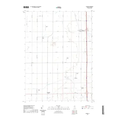
2021 Map of Steward
USGS Topo · Published 2021About this map
The village of Steward sits at the northern end of this Lee County landscape, centered at the intersection of Main St, Steward St, and John St. In the southern reaches, the small settlement of Scarboro and the crossroads at Twelvemile Corner punctuate a vast agricultural grid defined by family-named routes such as Gittleson Rd, Rochelle Rd, and German Rd. This 2021 survey illustrates a region where localized air travel and heritage are prominent, evidenced by numerous private airstrips like Durin RLA Airport and Hep Cats Airport. The terrain is drained by several waterways, including the Green River, Steward Cr, and Willow Creek, while local history is preserved at sites like Saint Marys Twin Grove German Cem and Steward Cem.
Find a feature on this map
43 named features on this map. Tap any name to fly to it.
Don’t see what you’re looking for? This feature index may not catch every label — zoom into the map to look around manually.
Map Details
Editions of this 2021 Steward Map
This is the sole edition of this map. No revisions or reprints were ever made.
Other maps of this area

1934 · De Kalb
USGS Topo · 1:62,500

1937 · De Kalb
USGS Topo · 1:62,500

1951 · Earlville
USGS Topo · 1:62,500

1952 · Rochelle
USGS Topo · 1:62,500

1952 · Mendota
USGS Topo · 1:62,500

1958 · Aurora
USGS Topo · 1:250,000

1961 · Aurora
USGS Topo · 1:250,000
1971 · Lee
USGS Topo · 1:24,000
1971 · Paw Paw
USGS Topo · 1:24,000
1971 · Creston
USGS Topo · 1:24,000