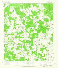
1963 Map of Stewards Mill
USGS Topo · Published 1966About this map
Stewards Mill and the surrounding Freestone County countryside are documented here in the early 1960s, revealing a landscape defined by small rural hubs and dispersed family burial grounds. The settlement pattern is anchored by locations like Bonnerville and Rhode Island, while the economy is marked by the presence of several Gas Well sites scattered throughout the terrain. Genealogists will find this particular survey especially useful for its high density of small cemeteries, including the Old Antioch Cem, Johnson Cem, Bateman Cem, and the Day Cem.
Find a feature on this map
25 named features on this map. Tap any name to fly to it.
Don’t see what you’re looking for? This feature index may not catch every label — zoom into the map to look around manually.
Map Details
Editions of this 1963 Stewards Mill Map
2 editions found
Other maps of this area

1919 · Fairfield
USGS Topo · 1:62,500

1920 · Mexia
USGS Topo · 1:62,500

1954 · Waco
USGS Topo · 1:250,000

1955 · Waco
USGS Topo · 1:250,000

1960 · Winkler
USGS Topo · 1:24,000

1960 · Streetman
USGS Topo · 1:24,000

1960 · Roustabout Camp
USGS Topo · 1:24,000

1961 · Young
USGS Topo · 1:24,000

1963 · Teague North
USGS Topo · 1:24,000

1963 · Kirvin
USGS Topo · 1:24,000