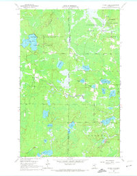
1964 Map of Stingy Lake
USGS Topo · Published 1974About this map
George Washington State Forest and Sturgeon River State Forest dominate this mid-century landscape on the border of Itasca and St. Louis counties. The map captures a largely undeveloped northern wilderness defined by a dense network of glacial water bodies, including Stingy Lake, Lake Twentyfour, and the elongated Moose Lake. This 1964 survey reveals the industrial and recreational character of the region during the 1960s, showing a reliance on natural resources as evidenced by several Gravel Pits and timber management areas. Water flows through the center of the sheet via Day Brook, while the East River and Rock Creek drain the southern marshes. Human impact is restricted to a few unpaved roads and a single Trail cutting through the northeast corner of the Superior National Forest, preserving a view of the Iron Range backcountry before modern expansion.
Find a feature on this map
27 named features on this map. Tap any name to fly to it.
Don’t see what you’re looking for? This feature index may not catch every label — zoom into the map to look around manually.
Map Details
Editions of this 1964 Stingy Lake Map
4 editions found
Other maps of this area

1951 · Hibbing
USGS Topo · 1:24,000

1952 · Keewatin
USGS Topo · 1:24,000

1952 · Nashwauk
USGS Topo · 1:24,000

1954 · Hibbing
USGS Topo · 1:250,000

1955 · Dewey Lake NW
USGS Topo · 1:24,000

1955 · Dewey Lake
USGS Topo · 1:24,000

1957 · Hibbing
USGS Topo · 1:250,000

1957 · Hibbing
USGS Topo · 1:24,000

1958 · Hibbing
USGS Topo · 1:250,000

1964 · Hibbing
USGS Topo · 1:250,000