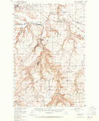
1955 Map of Stockett
USGS Topo · Published 1965About this map
Malmstrom Air Force Base overlooks the high plains south of Great Falls, where the industrial and military presence of the mid-1950s meets the legacy of early coal mining and homesteading. The deeply carved drainage of Sand Coulee Creek serves as the primary corridor for settlement, linking the mining and railroad towns of Sandcoulee, Centerville, and Stockett. This rugged landscape is defined by its social infrastructure, featuring a dense network of country schoolhouses such as New Century Sch and Flemming Sch, alongside numerous community burial grounds like Sandcoulee Cem and Tiger Butte Cem. The Great Northern railway line winds through the coulees, tracing the path of commerce that established these small Cascades County communities. The map highlights the transition from the flat agricultural expanses of Gibson Flats to the broken, benchland terrain of Cottonwood Bench.
Find a feature on this map
47 named features on this map. Tap any name to fly to it.
Don’t see what you’re looking for? This feature index may not catch every label — zoom into the map to look around manually.
Map Details
Editions of this 1955 Stockett Map
3 editions found

Other maps of this area

1886 · Great Falls
USGS Topo · 1:250,000

1890 · Fort Benton
USGS Topo · 1:250,000

1892 · Fort Benton
USGS Topo · 1:250,000

1897 · Fort Benton
USGS Topo · 1:250,000

1948 · Portage
USGS Topo · 1:62,500

1949 · Portage
USGS Topo · 1:62,500

1949 · Great Falls
USGS Topo · 1:62,500

1951 · Great Falls
USGS Topo · 1:62,500

1954 · Great Falls
USGS Topo · 1:250,000

1954 · Waltham
USGS Topo · 1:24,000