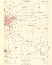
1952 Map of Stockton East
USGS Topo · Published 1954About this map
Stockton's eastern expansion is clearly visible in this early 1950s survey, showing the transition from dense urban development to the surrounding agricultural landscapes of San Joaquin County. The landscape is defined by its complex water management and transportation infrastructure, featuring the Stockton Diverting Canal and several significant waterways like Mormon Slough and Duck Creek. The era's industrial and military presence is anchored by Stockton Field (the municipal airport) and the Sharpe General Depot, while three major rail lines—the Southern Pacific, Atchison Topeka and Santa Fe, and Tidewater Southern—crisscross the territory. Local education is represented by numerous neighborhood institutions including Franklin High Sch and Elmwood Sch, serving the residential pockets of Fair Oaks and outlying settlements like Collegeville.
Find a feature on this map
39 named features on this map. Tap any name to fly to it.
Don’t see what you’re looking for? This feature index may not catch every label — zoom into the map to look around manually.
Map Details
Editions of this 1952 Stockton East Map
3 editions found
Other maps of this area

1894 · Lodi
USGS Topo · 1:125,000

1908 · Waterloo
USGS Topo · 1:31,680

1908 · Linden
USGS Topo · 1:31,680

1910 · Castle
USGS Topo · 1:31,680

1913 · Stockton
USGS Topo · 1:31,680

1914 · Burnham
USGS Topo · 1:31,680

1914 · Manteca
USGS Topo · 1:31,680

1914 · Avena
USGS Topo · 1:31,680

1915 · Lathrop
USGS Topo · 1:31,680

1915 · Peters
USGS Topo · 1:31,680