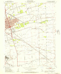
1952 Map of Stockton East
USGS Topo · Published 1954About this map
Stockton radiates eastward during the early 1950s, its urban grid giving way to a dense network of orchards and vegetable fields crisscrossed by competing rail lines. The agricultural landscape is defined by the Stockton Diverting Canal and natural waterways like Mormon Slough and Duck Creek, which dictated the placement of early ranch roads and settlements. Local education is anchored by several rural institutions, including Franklin High Sch and Elmwood Sch, serving the surrounding farming communities.
Find a feature on this map
37 named features on this map. Tap any name to fly to it.
Don’t see what you’re looking for? This feature index may not catch every label — zoom into the map to look around manually.
Map Details
Editions of this 1952 Stockton East Map
3 editions found
Other maps of this area

1894 · Lodi
USGS Topo · 1:125,000

1908 · Waterloo
USGS Topo · 1:31,680

1908 · Linden
USGS Topo · 1:31,680

1910 · Castle
USGS Topo · 1:31,680

1913 · Stockton
USGS Topo · 1:31,680

1914 · Burnham
USGS Topo · 1:31,680

1914 · Manteca
USGS Topo · 1:31,680

1914 · Avena
USGS Topo · 1:31,680

1915 · Lathrop
USGS Topo · 1:31,680

1915 · Peters
USGS Topo · 1:31,680