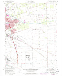
1968 Map of Stockton East
USGS Topo · Published 1977About this map
Stockton serves as the focal point for this survey, revealing the eastward expansion of the city during the late 1960s and 1970s. The landscape is defined by its sophisticated water management and transportation networks, featuring the Stockton Diverting Canal, Mormon Slough, and Duck Creek. Notable institutional presence is marked by the sprawling Northern California Youth Center and the Sharpe Army Depot (Field Annex), which anchor the southern half of the map alongside the Stockton Metropolitan Airport. The agricultural character of the outskirts is punctuated by small settlements like Collegeville and Littlejohns, and numerous local education sites such as Franklin High Sch and Chartville Sch. A heavy rail presence is evident, with the Southern Pacific, Tidewater Southern, and Atchison Topeka and Santa Fe lines crisscrossing the valley floor, highlighting the region's importance as a logistical hub.
Find a feature on this map
49 named features on this map. Tap any name to fly to it.
Don’t see what you’re looking for? This feature index may not catch every label — zoom into the map to look around manually.
Map Details
Editions of this 1968 Stockton East Map
4 editions found
Other maps of this area

1894 · Lodi
USGS Topo · 1:125,000

1908 · Waterloo
USGS Topo · 1:31,680

1908 · Linden
USGS Topo · 1:31,680

1910 · Castle
USGS Topo · 1:31,680

1913 · Stockton
USGS Topo · 1:31,680

1914 · Burnham
USGS Topo · 1:31,680

1914 · Manteca
USGS Topo · 1:31,680

1914 · Avena
USGS Topo · 1:31,680

1915 · Lathrop
USGS Topo · 1:31,680

1915 · Peters
USGS Topo · 1:31,680