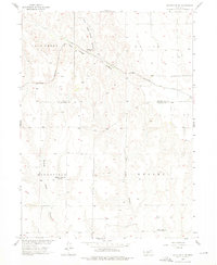
1956 Map of Stockville NE
USGS Topo · Published 1976About this map
The Chicago Burlington and Quincy railroad cuts a diagonal path across this Frontier County landscape, following the natural contours of the Loess Hills. This mid-century survey captures a rural environment in transition, where the infrastructure of early settlement has begun to fade. The landscape is defined by the deep incisions of Deer Creek Canyon and Deer Creek, which break the upland plains into the distinct topographic regions of Walker, Moorefield, and Russell.
Find a feature on this map
13 named features on this map. Tap any name to fly to it.
Don’t see what you’re looking for? This feature index may not catch every label — zoom into the map to look around manually.
Map Details
Editions of this 1956 Stockville NE Map
2 editions found
Other maps of this area

1902 · Gothenburg
USGS Topo · 1:125,000

1954 · McCook
USGS Topo · 1:250,000

1956 · Jeffrey Reservoir SW
USGS Topo · 1:24,000

1956 · Stockville NE
USGS Topo · 1:24,000

1956 · Moorefield
USGS Topo · 1:24,000

1956 · Stockville
USGS Topo · 1:24,000

1956 · Stockville SE
USGS Topo · 1:24,000

1957 · McCook
USGS Topo · 1:250,000

1958 · McCook
USGS Topo · 1:250,000
1970 · Eustis SW
USGS Topo · 1:24,000