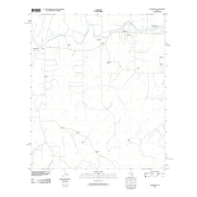
2010 Map of Stonewall
USGS Topo · Published 2010About this map
The Pedernales River carves through the northern reaches of this Gillespie County landscape, anchoring the settlement of Stonewall and the nearby Lyndon B Johnson State Park Dam. This area of the Texas Hill Country is defined by a dense network of family-owned ranchlands, where names like Franz Ranch, Weinheimer Ranch, and Schladoer Ranch reflect generations of local agricultural history. The map records several smaller settlements and hubs, including Blumenthal and the roads branching off Ranch Rd 1376. Numerous watercourses such as South Grape Creek and Threemile Creek drain the terrain toward the river. For genealogists, the inclusion of the Luckenbach Cemetery, Stonewall Cemetery, and Guadalupe Cemetery provides vital geographic anchors for tracing family roots within these rural communities.
Find a feature on this map
31 named features on this map. Tap any name to fly to it.
Don’t see what you’re looking for? This feature index may not catch every label — zoom into the map to look around manually.
Map Details
Editions of this 2010 Stonewall Map
This is the sole edition of this map. No revisions or reprints were ever made.
Other maps of this area

1894 · Fredericksburg
USGS Topo · 1:125,000

1954 · Llano
USGS Topo · 1:250,000

1955 · Llano
USGS Topo · 1:250,000

1956 · Llano
USGS Topo · 1:250,000

1961 · Stonewall
USGS Topo · 1:24,000

1961 · Hye
USGS Topo · 1:24,000

1961 · Cave Creek School
USGS Topo · 1:24,000

1961 · Rocky Creek
USGS Topo · 1:24,000
1963 · Crabapple Creek
USGS Topo · 1:24,000

1963 · Whitworth Ranch
USGS Topo · 1:24,000