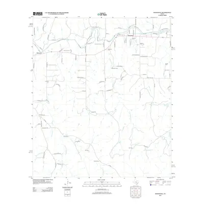
2012 Map of Stonewall
USGS Topo · Published 2012About this map
The Pedernales River carves through this Gillespie County landscape, anchoring the community of Stonewall and the smaller settlement of Blumenthal to the west. This 2012 survey illustrates a region defined by long-standing family landholdings and agricultural heritage, where the grid of rural roads connects numerous named properties such as Brehmer Ranch, Schladoer Ranch, and Wehmeyer Ranch. Local history is preserved in several burial grounds, including the Stonewall Cem near the river and the Luckenbach Cem situated near the banks of S Grape Cr.
Find a feature on this map
87 named features on this map. Tap any name to fly to it.
Don’t see what you’re looking for? This feature index may not catch every label — zoom into the map to look around manually.
Map Details
Editions of this 2012 Stonewall Map
This is the sole edition of this map. No revisions or reprints were ever made.
Other maps of this area

1894 · Fredericksburg
USGS Topo · 1:125,000

1954 · Llano
USGS Topo · 1:250,000

1955 · Llano
USGS Topo · 1:250,000

1956 · Llano
USGS Topo · 1:250,000

1961 · Stonewall
USGS Topo · 1:24,000

1961 · Hye
USGS Topo · 1:24,000

1961 · Cave Creek School
USGS Topo · 1:24,000

1961 · Rocky Creek
USGS Topo · 1:24,000
1963 · Crabapple Creek
USGS Topo · 1:24,000

1963 · Whitworth Ranch
USGS Topo · 1:24,000