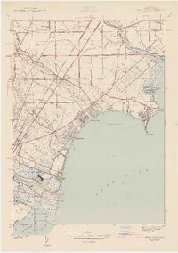
1942 Map of Stony Point
USGS Topo · Published 1942About this map
Lake Erie defines the eastern edge of this 1940 survey, where a string of shoreline communities like Woodland Beach, Detroit Beach, and Lagoon Beach demonstrate the mid-century development of the Michigan coast. The City of Monroe occupies the southwestern corner, anchored by the River Raisin and the Sterling State Park marshlands. Inland, the landscape is heavily influenced by the drainage network of Swan Creek, Stony Creek, and Sandy Creek, interspersed with a dense system of rural schools including Scrabble Hollow Sch, Loranger Sch, and Bomia Sch. Transport corridors dominate the interior, with the Michigan Central and Toledo Shore Line railroads running parallel to major arteries like Dixie Hy and Telegraph Rd. The map also captures local landmarks such as the Monroe Airport and the St Charles Cem, providing a detailed look at the township boundaries of Frenchtown, Berlin, and Monroe.
Find a feature on this map
74 named features on this map. Tap any name to fly to it.
Don’t see what you’re looking for? This feature index may not catch every label — zoom into the map to look around manually.
Map Details
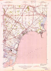
Editions of this 1942 Stony Point Map
2 editions found
Other maps of this area

1906 · Wyandotte
USGS Topo · 1:62,500

1906 · Romulus
USGS Topo · 1:62,500

1912 · Wyandotte
USGS Topo · 1:62,500

1912 · Monroe
USGS Topo · 1:62,500

1914 · Monroe
USGS Topo · 1:62,500

1927 · Monroe
USGS Topo · 1:31,680

1928 · Romulus
USGS Topo · 1:62,500

1929 · Wyandotte
USGS Topo · 1:62,500

1936 · Rockwood
USGS Topo · 1:31,680

1936 · Stony Point
USGS Topo · 1:31,680
Featured Places
- Frenchtown Charter Township, MI
- Monroe, MI
- Monroe Charter Township, MI
- Berlin Charter Township, MI
- Detroit Beach, Frenchtown Charter Township