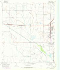
1962 Map of Stowell
USGS Topo · Published 1978About this map
Sea Breeze Oil Field dominates the southern landscape of this coastal Texas region, where a dense network of pipelines and disposal wells reveals the intensity of mid-century petroleum extraction. The adjacent communities of Winnie and Stowell serve as the primary residential and commercial hubs, situated at a critical crossroads of heavy-duty transport. The presence of Grain Elevators along the Gulf Colorado and Santa Fe railroad line highlights the dual importance of oil and agriculture to the local economy.
Find a feature on this map
21 named features on this map. Tap any name to fly to it.
Don’t see what you’re looking for? This feature index may not catch every label — zoom into the map to look around manually.
Map Details
Editions of this 1962 Stowell Map
3 editions found
Other maps of this area

1943 · Whites Bayou
USGS Topo · 1:24,000

1943 · Sea Breeze
USGS Topo · 1:24,000

1943 · Stowell
USGS Topo · 1:24,000

1945 · Nolte
USGS Topo · 1:31,680

1945 · Sea Breeze
USGS Topo · 1:31,680

1950 · Houston
USGS Topo · 1:250,000

1956 · Houston
USGS Topo · 1:250,000
1961 · Monroe City
USGS Topo · 1:24,000
1961 · Oyster Bayou
USGS Topo · 1:24,000
1961 · Whites Bayou
USGS Topo · 1:24,000