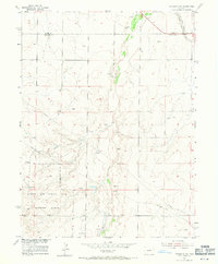
1955 Map of Strasburg NW
USGS Topo · Published 1971About this map
Lowry Air Force Base Bombing Range occupies a significant portion of the southern landscape in this mid-century survey, its northern extent defined by the Military Reservation Boundary. The terrain is characterized by the winding path of Kiowa Creek, which is flanked by numerous Windmills across the high plains. Industrial and infrastructure developments of the 1950s are prominent, including a Gravel Pit, a Pipeline, and a Telephone Line cutting across the sections.
Find a feature on this map
12 named features on this map. Tap any name to fly to it.
Don’t see what you’re looking for? This feature index may not catch every label — zoom into the map to look around manually.
Map Details
Editions of this 1955 Strasburg NW Map
4 editions found
Other maps of this area

1890 · East Denver
USGS Topo · 1:125,000

1949 · Bennett
USGS Topo · 1:24,000

1950 · Roper School
USGS Topo · 1:24,000

1951 · Roper School
USGS Topo · 1:24,000

1951 · Manila
USGS Topo · 1:24,000

1953 · Denver
USGS Topo · 1:250,000

1954 · Watkins
USGS Topo · 1:24,000

1955 · Strasburg NW
USGS Topo · 1:24,000

1955 · Watkins SE
USGS Topo · 1:24,000

1955 · Strasburg
USGS Topo · 1:24,000