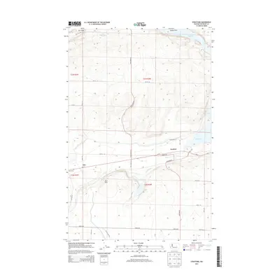
2014 Map of Stratford
USGS Topo · Published 2014About this map
Stratford and the nearby rail point at Adco Siding anchor this landscape in Grant County, where the agricultural flats of the Columbia Basin meet the distinct basalt coulee formations of central Washington. The topography is defined by the winding course of Crab Creek and the significant water storage at Billy Clapp Lake in the north. This 2014 survey illustrates the complex intersection of natural drainage and modern irrigation infrastructure, with Sprague Draw and Dry Coulee marking the ancient glacial pathways through the terrain. A network of rural roads, including Pinto Ridge Rd and Stratford Rd, connects isolated ranching and farming operations across the township lines. Prominent landmarks such as Black Butte rise above the basin floor, while Brook Lake sits just east of the main settlement, providing a detailed look at the region's hydrography before it feeds into the larger Crab Creek system.
Find a feature on this map
34 named features on this map. Tap any name to fly to it.
Don’t see what you’re looking for? This feature index may not catch every label — zoom into the map to look around manually.
Map Details
Editions of this 2014 Stratford Map
This is the sole edition of this map. No revisions or reprints were ever made.
Other maps of this area

1953 · Ritzville
USGS Topo · 1:250,000

1956 · Stratford
USGS Topo · 1:24,000

1956 · Grant Orchards
USGS Topo · 1:24,000

1956 · Gloyd
USGS Topo · 1:24,000

1956 · Wilson Creek SW
USGS Topo · 1:24,000

1956 · Wilson Creek NW
USGS Topo · 1:24,000

1956 · Soap Lake
USGS Topo · 1:24,000

1956 · Wilson Creek
USGS Topo · 1:62,500

1959 · Ritzville
USGS Topo · 1:250,000

1965 · Ritzville
USGS Topo · 1:250,000