
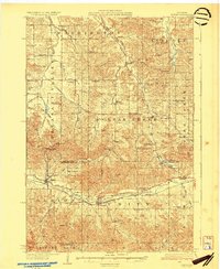
1930 Map of Strum
USGS Topo · Published 1930About this map
Buffalo River winds through the southern reaches of this landscape, anchoring the settlements of Eleva and Strum during the late 1920s. This survey captures a rural Wisconsin economy defined by its valleys, including Pleasant Valley, Fall Creek Valley, and York Valley, which channeled early roads and trade. The Chicago St Paul Minneapolis and Omaha railroad follows the river course, providing a vital link for the scattered farming communities. Numerous country schools like Norwegian High Sch, Plainview Sch, and Gueisler Sch are meticulously plotted alongside local landmarks such as Zion Ch and the Hadleyville Cem. The map reveals a high density of named valleys and small hamlets like Cleghorn, Brackett, and Foster, illustrating the established social fabric of Trempealeau and Eau Claire counties before the modernization of the mid-century highway system.
Find a feature on this map
66 named features on this map. Tap any name to fly to it.
Don’t see what you’re looking for? This feature index may not catch every label — zoom into the map to look around manually.
Map Details
Editions of this 1930 Strum Map
2 editions found
Other maps of this area

1926 · Whitehall
USGS Topo · 1:62,500

1927 · Blair
USGS Topo · 1:62,500

1927 · Strum
USGS Topo · 1:62,500

1929 · Whitehall
USGS Topo · 1:62,500

1932 · Gilmanton
USGS Topo · 1:62,500

1932 · Mondovi
USGS Topo · 1:62,500

1934 · Elk Mound
USGS Topo · 1:62,500

1934 · Chippewa Falls
USGS Topo · 1:62,500

1935 · Osseo
USGS Topo · 1:48,000

1936 · Chippewa Falls
USGS Topo · 1:62,500