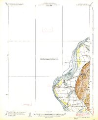
1926 Map of Sugar Lake
USGS Topo · Published 1926About this map
Missouri River oxbows and bottomlands dominate this mid-1920s survey of the border region between Missouri and Kansas. The landscape is defined by the shifting course of the river, which has left behind significant bodies of water like Sugar Lake and Mud Lake. These wetlands and fertile plains supported a dense network of rural education, evidenced by the numerous local schoolhouses such as Fairview School, Pleasant Valley School, and Enterprise School that served the farming families of Marshall and the surrounding area.
Find a feature on this map
23 named features on this map. Tap any name to fly to it.
Don’t see what you’re looking for? This feature index may not catch every label — zoom into the map to look around manually.
Map Details
Editions of this 1926 Sugar Lake Map
5 editions found

Other maps of this area

1885 · Atchison
USGS Topo · 1:125,000

1886 · Oskaloosa
USGS Topo · 1:125,000

1888 · Oskaloosa
USGS Topo · 1:125,000

1888 · Atchison
USGS Topo · 1:125,000

1890 · Kansas City
USGS Topo · 1:125,000

1893 · Atchison
USGS Topo · 1:125,000

1894 · Kansas City
USGS Topo · 1:125,000

1894 · Oskaloosa
USGS Topo · 1:125,000

1910 · Leavenworth
USGS Topo · 1:62,500

1924 · St. Joseph
USGS Topo · 1:62,500