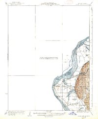
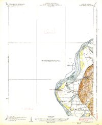
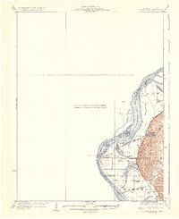
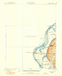
1926 Map of Sugar Lake
USGS Topo · Published 1938About this map
The Missouri River defines the landscape of this western Missouri and eastern Kansas border region, weaving between Atchison, Doniphan, and Buchanan Counties. The map reveals a complex riverine environment where oxbow features like Sugar Lake, Mud Lake, and Singleton Lake dominate the floodplain west of the rising bluffs. Near the hub of Rushville, the terrain shifts toward more elevated country, providing a topographical contrast to the low-lying river bottom. This 1920s-era landscape is heavily structured by the rail lines of the Chicago Burlington and Quincy and the Chicago and Alton railroads, which facilitated movement through vital transit points like East Atchison Winthrop Station. Local life is further evidenced by a dense network of rural schoolhouses, including Wilson School, Fairview School, and Block School, serving the farming communities of Marshall and the surrounding townships.
Find a feature on this map
24 named features on this map. Tap any name to fly to it.
Don’t see what you’re looking for? This feature index may not catch every label — zoom into the map to look around manually.
Map Details
Editions of this 1926 Sugar Lake Map
5 editions found

Other maps of this area

1885 · Atchison
USGS Topo · 1:125,000

1886 · Oskaloosa
USGS Topo · 1:125,000

1888 · Oskaloosa
USGS Topo · 1:125,000

1888 · Atchison
USGS Topo · 1:125,000

1890 · Kansas City
USGS Topo · 1:125,000

1893 · Atchison
USGS Topo · 1:125,000

1894 · Kansas City
USGS Topo · 1:125,000

1894 · Oskaloosa
USGS Topo · 1:125,000

1910 · Leavenworth
USGS Topo · 1:62,500

1924 · St. Joseph
USGS Topo · 1:62,500