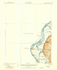
1926 Map of Sugar Lake
USGS Topo · Published 1950About this map
The Missouri River forms a dynamic boundary between Missouri and Kansas, carving a landscape defined by oxbow lakes and fertile floodplains. Near the hub of Atchison, the rail-and-river economy is evident in the presence of the Chicago Rock Island and Pacific and Chicago Burlington and Quincy railroads, which converge near the settlement of Armour. The terrain is marked by remnant water bodies like Sugar Lake, Mud Lake, and Singleton Lake, indicating the river's shifting course over time.
Find a feature on this map
27 named features on this map. Tap any name to fly to it.
Don’t see what you’re looking for? This feature index may not catch every label — zoom into the map to look around manually.
Map Details
Editions of this 1926 Sugar Lake Map
5 editions found

Other maps of this area

1885 · Atchison
USGS Topo · 1:125,000

1886 · Oskaloosa
USGS Topo · 1:125,000

1888 · Oskaloosa
USGS Topo · 1:125,000

1888 · Atchison
USGS Topo · 1:125,000

1890 · Kansas City
USGS Topo · 1:125,000

1893 · Atchison
USGS Topo · 1:125,000

1894 · Kansas City
USGS Topo · 1:125,000

1894 · Oskaloosa
USGS Topo · 1:125,000

1910 · Leavenworth
USGS Topo · 1:62,500

1924 · St. Joseph
USGS Topo · 1:62,500