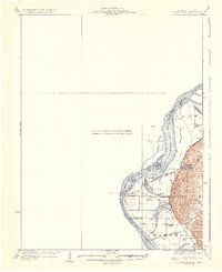
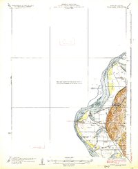
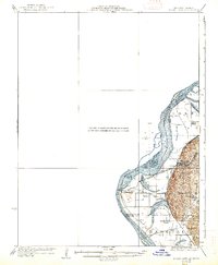
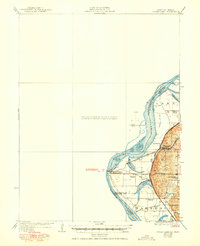
1926 Map of Sugar Lake
USGS Topo · Published 1926About this map
The Missouri River defines the western edge of this 1920s survey, illustrating a landscape shaped by both the river's winding course and the heavy footprint of the railroad. Industrial and logistical hubs like Rushville and Armour are situated along the eastern bluffs, while Winthrop Sta and East Atchison facilitate connections across the water into Kansas. The floodplain is dotted with several oxbow lakes, including Mud Lake, Singleton Lake, and the prominent Sugar Lake, which sits within the Marshall district.
Find a feature on this map
26 named features on this map. Tap any name to fly to it.
Don’t see what you’re looking for? This feature index may not catch every label — zoom into the map to look around manually.
Map Details
Editions of this 1926 Sugar Lake Map
5 editions found

Other maps of this area

1885 · Atchison
USGS Topo · 1:125,000

1886 · Oskaloosa
USGS Topo · 1:125,000

1888 · Oskaloosa
USGS Topo · 1:125,000

1888 · Atchison
USGS Topo · 1:125,000

1890 · Kansas City
USGS Topo · 1:125,000

1893 · Atchison
USGS Topo · 1:125,000

1894 · Kansas City
USGS Topo · 1:125,000

1894 · Oskaloosa
USGS Topo · 1:125,000

1910 · Leavenworth
USGS Topo · 1:62,500

1924 · St. Joseph
USGS Topo · 1:62,500