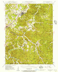
1947 Map of Sullivan
USGS Topo · Published 1957About this map
Meramec State Park and the subterranean wonders of the Meramec River basin define this mid-century landscape. The area is dense with geological landmarks, from the well-known Meramec Caverns and Onondaga Cave to more obscure sites like Mushroom Cave and Cathedral Cave. The town of Sullivan serves as a hub where the ST Louis San Francisco railroad cuts through the terrain. Away from the main line, a high concentration of rural schoolhouses such as Anthonies Mill Sch, Reeds Defeat Sch, and Barker Sch suggests a late-era peak of small, localized school districts. The southern reaches are heavily wooded, containing portions of Clark National Forest and industrial traces like the Old Christy Mine. This period reveals a transition where the timber and mining economies of the Ozark foothills intersect with an emerging recreation industry centered on the river and its many limestone caves.
Find a feature on this map
93 named features on this map. Tap any name to fly to it.
Don’t see what you’re looking for? This feature index may not catch every label — zoom into the map to look around manually.
Map Details
Editions of this 1947 Sullivan Map
3 editions found

Other maps of this area

1901 · De Soto
USGS Topo · 1:125,000

1903 · Sullivan
USGS Topo · 1:125,000

1906 · Potosi
USGS Topo · 1:62,500

1932 · Steelville
USGS Topo · 1:48,000

1933 · Steelville
USGS Topo · 1:62,500

1934 · Meramec State Park
USGS Topo · 1:24,000

1935 · Gerald
USGS Topo · 1:48,000

1937 · Steelville
USGS Topo · 1:62,500

1937 · Meramec State Park
USGS Topo · 1:24,000

1941 · Gerald
USGS Topo · 1:62,500