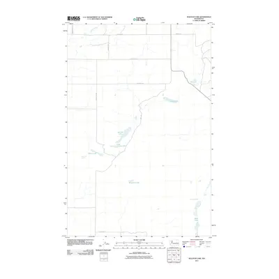
2011 Map of Sullivan Lake
USGS Topo · Published 2011About this map
Sullivan Lake and Little Sullivan Lake lie at the heart of this dryland plateau, where the landscape is defined by a network of seasonal coulees and intermittent water sources. This portion of Lincoln County showcases a rural agricultural grid, with long stretches of road including Brownswell Rd N and Schlimmer Rd E serving isolated farmsteads. The presence of several small, scattered water bodies such as Goetz Lake and Bulgarians Lake suggests a unique hydrology where drainage collects in local depressions. Named landmarks like Reiser Falls on Canniwai Creek and Delzer Falls near Lake Creek indicate sharp breaks in the basalt-heavy terrain, characteristic of the region’s geological history. Further south, Waukesha Spring and Bobs Lakes provide additional water points in an otherwise arid environment, connected by a sparse network of county roads like Irby Rd N.
Find a feature on this map
22 named features on this map. Tap any name to fly to it.
Don’t see what you’re looking for? This feature index may not catch every label — zoom into the map to look around manually.
Map Details
Editions of this 2011 Sullivan Lake Map
This is the sole edition of this map. No revisions or reprints were ever made.
Other maps of this area

1953 · Ritzville
USGS Topo · 1:250,000

1959 · Ritzville
USGS Topo · 1:250,000

1965 · Ritzville
USGS Topo · 1:250,000

1968 · Marlin SW
USGS Topo · 1:24,000

1968 · Irby
USGS Topo · 1:24,000

1968 · Marlin
USGS Topo · 1:24,000

1968 · Pacific Lake
USGS Topo · 1:24,000
1968 · Odessa
USGS Topo · 1:24,000

1968 · Sullivan Lake
USGS Topo · 1:24,000

1969 · Almira SE
USGS Topo · 1:24,000